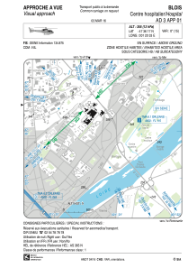


LFH29 - Blois Centre Hospitalier
Located in , France
ICAO - , IATA -
Data provided by AirmateGeneral information
Coordinates: N47°36'17" E1°20'33"
Elevation is 355 feet MSL.
Magnetic variation is 0.79° East View others Airports in Centre
Operational data
Special qualification required
Current time UTC:
Current local time:
Weather at : LFYR - Romorantin Pruniers ( 41 km )
METAR: LFYR 151930Z AUTO VRB02KT CAVOK 12/11 Q1006
TAF: TAF LFYR 151400Z 1515/1615 20007KT 9999 BKN040 TEMPO 1515/1520 VRB10G20KT 4000 SHRA BKN040CB PROB40 TEMPO 1515/1519 VRB15G30KT 2000 TSRA BKN040CB PROB30 TEMPO 1602/1605 0500 FG TEMPO 1610/1615 4000 SHRA BKN030CB
Communications frequencies: [VIEW]
Runways:
Airport contact information
Address: France