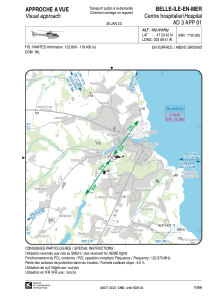


LFH281 - Belle-Ile-En-Mer Centre Hospitalier
Located in , France
ICAO - , IATA -
Data provided by AirmateGeneral information
Coordinates: N47°20'42" W3°9'41"
Elevation is 102 feet MSL.
Magnetic variation is 0.60° East View others Airports in Brittany
Operational data
Special qualification required
Current time UTC:
Current local time:
Weather at : LFRH - Lorient Lann Bihoue ( 51 km )
METAR: LFRH 160730Z AUTO 09008KT 070V130 9999 BKN008/// BKN013/// BKN019/// //////TCU 13/11 Q1002 TEMPO 2000 TSRA BKN008 BKN015CB
TAF: TAF LFRH 160500Z 1606/1706 13010KT 9999 BKN017 TEMPO 1606/1609 BKN008 SCT012TCU TEMPO 1609/1617 4000 SHRA SCT015CB BKN017 PROB40 TEMPO 1609/1616 2000 TSRA BKN008 BKN015CB TEMPO 1617/1619 SCT012TCU TEMPO 1702/1706 BKN008 PROB30 TEMPO 1705/1706 BKN003
Communications frequencies: [VIEW]
Runways:
Airport contact information
Address: France