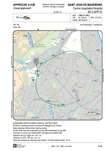


LFH21 - Saint Jean De Maurienne Centre Hospitalier
Located in , France
ICAO - , IATA -
Data provided by AirmateGeneral information
Coordinates: N45°16'40" E6°20'30"
Elevation is 1983 feet MSL.
Magnetic variation is 2.20° East View others Airports in Midi-Pyrénées
Operational data
Special qualification required
Current time UTC:
Current local time:
Weather at : LFLB - Chambery Aix Les Bains ( 54 km )
METAR: LFLB 221500Z AUTO 02004KT 330V060 9999 FEW074 21/10 Q1013 TEMPO 4500 SHRA SCT040TCU
TAF: TAF LFLB 221400Z 2215/2315 VRB02KT 9999 SCT040 PROB30 TEMPO 2215/2301 36010KT 4500 SHRA SCT040TCU TEMPO 2306/2312 4000 SHRA SCT014 FEW030CB BKN040TCU
Communications frequencies: [VIEW]
Runways:
Airport contact information
Address: France