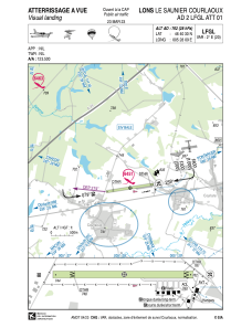


LFGL - Lons Le Saunier Courlaoux
Located in Lons Le Saunier, France
ICAO - LFGL, IATA - XLL
Data provided by AirmateGeneral information
Coordinates: N46°40'30" E5°28'9"
Elevation is 762 feet MSL.
Magnetic variation is 1.97° East View others Airports in Franche-Comté
Operational data
Special qualification required
Current time UTC:
Current local time:
Weather at : LFGJ - Dole Tavaux ( 41 km )
TAF: TAF LFGJ 151400Z 1515/1524 24005KT 9999 FEW025TCU SCT035 BKN080 TEMPO 1515/1524 -SHRA FEW025CB PROB30 TEMPO 1515/1524 4000 TSRA PROB30 TEMPO 1522/1524 BKN008
Communications frequencies: [VIEW]
Runways:
| RWY identifier | QFU | Length (ft) | Width (ft) | Surface | LDA (ft) |
| 08 | 81° | 3609 | 197 | GRASS | 3084 |
| 26 | 261° | 3609 | 197 | GRASS | 3379 |
Airport contact information
Address: Lons Le Saunier France

