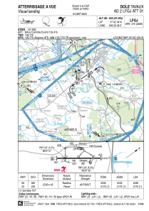


LFGJ - Dole Tavaux
Located in Dole, France
ICAO - LFGJ, IATA - DLE
Data provided by AirmateGeneral information
Coordinates: N47°2'34" E5°26'6"
Elevation is 645 feet MSL.
Magnetic variation is 1.96° East View others Airports in Franche-Comté
Operational data
Special qualification required
Current time UTC:
Current local time:
Weather
METAR: LFGJ 221030Z AUTO 24008KT 210V270 9000 SCT022/// OVC100/// //////TCU 18/12 Q1014 TEMPO 4000 TSRA FEW030CB
TAF: TAF LFGJ 220800Z 2209/2218 22010KT 9999 SCT015 BKN040 TEMPO 2209/2218 SHRA FEW030CB PROB40 TEMPO 2209/2210 BKN014 PROB30 TEMPO 2209/2216 VRB10KT 4000 TSRA
Communications frequencies: [VIEW]
Runways:
| RWY identifier | QFU | Length (ft) | Width (ft) | Surface | LDA (ft) |
| 05 | 54° | 7316 | 148 | MACADAM | 7316 |
| 23 | 234° | 7316 | 148 | MACADAM | 7136 |
Airport contact information
Address: Dole France

