


LFFY - Etrepagny
Located in Etrepagny, France
ICAO - LFFY, IATA -
Data provided by AirmateGeneral information
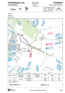
Coordinates: N49°18'19" E1°38'16"
Elevation is 308 feet MSL.
Magnetic variation is 0.78° East View others Airports in Upper Normandy
Operational data
Special qualification required
Current time UTC:
Current local time:
Weather at : LFOP - Rouen Vallee De Seine ( 34 km )
METAR: LFOP 221800Z AUTO 28011KT 9999 FEW034/// ///CB 17/11 Q1012 TEMPO 4000 SHRA BECMG BKN030
TAF: TAF LFOP 221400Z 2215/2224 25008KT 9999 BKN030 TEMPO 2215/2219 4000 SHRA BKN025TCU PROB40 TEMPO 2215/2218 2000 TSRA BKN025CB
Communications frequencies: [VIEW]
Runways:
| RWY identifier | QFU | Length (ft) | Width (ft) | Surface | LDA (ft) |
| 11 | 115° | 2215 | 164 | GRASS | |
| 29 | 295° | 2215 | 164 | GRASS |
Airport contact information
Address: Etrepagny France
