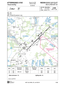


LFER - Redon Bains Sur Oust
Located in Redon, France
ICAO - LFER, IATA - XRN
Data provided by AirmateGeneral information
Coordinates: N47°41'55" W2°2'17"
Elevation is 225 feet MSL.
Magnetic variation is -0.26° East View others Airports in Brittany
Operational data
Special qualification required
Current time UTC:
Current local time:
Weather at : LFRZ - Saint Nazaire Montoir ( 44 km )
TAF: TAF LFRZ 151700Z 1518/1618 21013KT 9999 BKN025 BECMG 1520/1522 15008KT TEMPO 1604/1618 3000 SHRA BKN008 BKN020TCU TEMPO 1606/1618 BKN018CB
Communications frequencies: [VIEW]
Runways:
| RWY identifier | QFU | Length (ft) | Width (ft) | Surface | LDA (ft) |
| 04 | 44° | 2756 | 66 | ASPH | 2756 |
| 22 | 224° | 2756 | 66 | ASPH | 2756 |
Airport contact information
Address: Redon France
