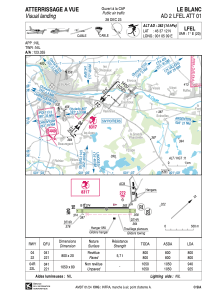


LFEL - Le Blanc
Located in Le Blanc, France
ICAO - LFEL, IATA -
Data provided by AirmateGeneral information
Coordinates: N46°37'12" E1°5'9"
Elevation is 382 feet MSL.
Magnetic variation is 0.77° East View others Airports in Centre
Operational data
Special qualification required
Current time UTC:
Current local time:
Weather at : LFLX - Chateauroux Deols ( 55 km )
METAR: LFLX 170200Z AUTO 12003KT CAVOK 07/07 Q1009 TEMPO 3000 BR
Communications frequencies: [VIEW]
Runways:
| RWY identifier | QFU | Length (ft) | Width (ft) | Surface | LDA (ft) |
| 04 | 42° | 2625 | 66 | ASPH | 2625 |
| 22 | 222° | 2625 | 66 | ASPH | 2625 |
| 04R | 42° | 3445 | 262 | GRASS | 3084 |
| 22L | 222° | 3445 | 262 | GRASS | 3035 |
Airport contact information
Address: Le Blanc France

