


LFEC - Ouessant
Located in Ouessant, France
ICAO - LFEC, IATA -
Data provided by AirmateGeneral information
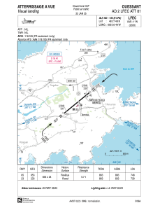
Coordinates: N48°27'48" W5°3'49"
Elevation is 142 feet MSL.
Magnetic variation is -1.35° East View others Airports in Brittany
Operational data
Special qualification required
Current time UTC:
Current local time:
Weather at : LFRB - Brest Bretagne ( 47 km )
METAR: LFRB 221500Z AUTO 29010KT 240V320 9999 FEW028 BKN038 BKN049 16/10 Q1014 TEMPO 4000 SHRA BKN025TCU SCT030CB
TAF: TAF LFRB 221100Z 2212/2318 28010KT 9999 BKN025 PROB40 TEMPO 2212/2216 4000 SHRA BKN025TCU SCT030CB BECMG 2220/2222 VRB05KT TEMPO 2222/2308 4000 SHRA BKN008 BKN025TCU PROB40 TEMPO 2300/2305 2000 BR TEMPO 2308/2311 2500 SHRA BKN008 BKN020CB BECMG 2308/2310 35010KT
Communications frequencies: [VIEW]
Runways:
| RWY identifier | QFU | Length (ft) | Width (ft) | Surface | LDA (ft) |
| 05 | 51° | 2733 | 79 | ASPH | 2454 |
| 23 | 231° | 2733 | 79 | ASPH | 2395 |
Airport contact information
Address: Ouessant France
