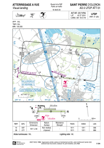


LFDP - Saint Pierre D'oleron
Located in , France
ICAO - LFDP, IATA -
Data provided by AirmateGeneral information
Coordinates: N45°57'28" W1°18'41"
Elevation is 22 feet MSL.
Magnetic variation is 0.09° East View others Airports in Poitou-Charentes
Operational data
Special qualification required
Current time UTC:
Current local time:
Weather at : LFBH - La Rochelle Ile De Re ( 26 km )
METAR: LFBH 151830Z AUTO 23011KT 200V260 9999 FEW029 14/09 Q1006 NOSIG
TAF: TAF LFBH 151700Z 1518/1618 22012KT 9999 SCT020 BKN070 TEMPO 1600/1618 23015G25KT 3000 SHRA SCT007 BKN020TCU TEMPO 1607/1612 BKN007 BKN018CB TEMPO 1612/1616 20015G27KT
Communications frequencies: [VIEW]
Runways:
| RWY identifier | QFU | Length (ft) | Width (ft) | Surface | LDA (ft) |
| 10 | 97° | 3317 | 164 | GRASS | 3071 |
| 28 | 277° | 3317 | 164 | GRASS | 2841 |
Airport contact information
Address: France

