


LFDL - Loudun
Located in Loudun, France
ICAO - LFDL, IATA -
Data provided by AirmateGeneral information
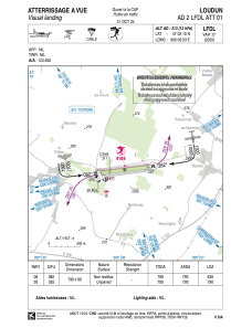
Coordinates: N47°2'10" E0°6'3"
Elevation is 313 feet MSL.
Magnetic variation is 0.45° East View others Airports in Poitou-Charentes
Operational data
Special qualification required
Current time UTC:
Current local time:
Weather at : LFBI - Poitiers Biard ( 52 km )
METAR: LFBI 151830Z AUTO 21005KT 160V230 9999 ///CB 13/10 Q1006 TEMPO 3000 SHRA
TAF: TAF LFBI 151700Z 1518/1618 20010KT 9999 SCT020 SCT045 TEMPO 1518/1521 3000 SHRA BKN025CB PROB40 TEMPO 1605/1607 BKN004 TEMPO 1610/1618 3000 SHRA SCT010 BKN025TCU TEMPO 1612/1618 BKN008 BKN018CB PROB30 TEMPO 1614/1617 TSRA
Communications frequencies: [VIEW]
Runways:
| RWY identifier | QFU | Length (ft) | Width (ft) | Surface | LDA (ft) |
| 08 | 83° | 2592 | 197 | GRASS | 2067 |
| 26 | 263° | 2592 | 197 | GRASS | 2592 |
Airport contact information
Address: Loudun France

