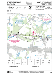


LFDF - Sainte Foy La Grande
Located in Sainte Foy La Grande, France
ICAO - LFDF, IATA -
Data provided by AirmateGeneral information
Coordinates: N44°51'9" E0°10'32"
Elevation is 282 feet MSL.
Magnetic variation is 0.59° East View others Airports in Aquitaine
Operational data
Special qualification required
Current time UTC:
Current local time:
Weather at : LFBE - Bergerac Dordogne Perigord ( 27 km )
METAR: LFBE 152000Z AUTO 20003KT 9999 //////CB 12/10 Q1008 BECMG BKN020
TAF: TAF LFBE 151100Z 1512/1612 26010KT 9999 BKN020 TEMPO 1512/1518 3000 SHRA BKN010 BKN020TCU PROB30 TEMPO 1512/1516 23015G25KT 1200 TSRA BKN005 BKN015CB BECMG 1518/1520 20005KT BECMG 1523/1601 VRB02KT PROB40 1601/1606 4000 BR BECMG 1606/1608 18005KT TEMPO 1609/1612 4000 SHRA BKN030TCU
Communications frequencies: [VIEW]
Runways:
| RWY identifier | QFU | Length (ft) | Width (ft) | Surface | LDA (ft) |
| 10 | 96° | 3937 | 197 | GRASS | 2854 |
| 28 | 276° | 3937 | 197 | GRASS | 3543 |
Airport contact information
Address: Sainte Foy La Grande France
