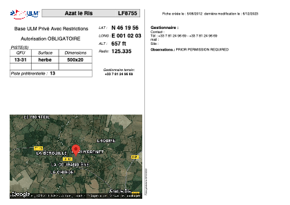


LF8755 - Azat le Ris
Located in Azat-le-Ris, France
ICAO - , IATA -
Data provided by AirmateGeneral information
Coordinates: N46°19'56" E1°2'3"
Elevation is 657 feet MSL.
View others Airports in Centre
Operational data
Special qualification required
Current time UTC:
Current local time:
Weather at : LFBL - Limoges Bellegarde ( 54 km )
METAR: LFBL 151830Z AUTO 07001KT 9999 //////TCU 10/09 Q1007 TEMPO 3000 SHRA BKN010 BKN020TCU BECMG 20010KT
TAF: TAF LFBL 151700Z 1518/1618 20010KT 9999 BKN030 TEMPO 1518/1522 3000 SHRA BKN010 BKN020TCU BECMG 1522/1524 VRB03KT 4000 BR BKN005 PROB40 1601/1606 0400 FG VV/// BECMG 1607/1609 19010KT 9999 NSW BKN015 TEMPO 1611/1618 4000 SHRA BKN015TCU PROB30 TEMPO 1613/1617 VRB15G25KT 1500 TSRA BKN010 BKN015CB
Communications frequencies: [VIEW]
Runways:
| RWY identifier | QFU | Length (ft) | Width (ft) | Surface | LDA (ft) |
| 13 | 0° | 1640 | 65 | GRASS | |
| 31 | 0° | 1640 | 65 | GRASS |
Airport contact information
Address: Azat-le-Ris France