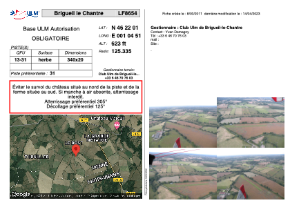


LF8654 - Brigueil le Chantre
Located in Brigueil-le-Chantre, France
ICAO - , IATA -
Data provided by AirmateGeneral information
Coordinates: N46°22'1" E1°4'51"
Elevation is 623 feet MSL.
View others Airports in Centre
Operational data
Special qualification required
Current time UTC:
Current local time:
Weather at : LFBL - Limoges Bellegarde ( 57 km )
TAF: TAF AMD LFBL 180846Z 1808/1906 VRB03KT CAVOK TEMPO 1808/1818 4000 -SHRA SCT005 BKN030TCU PROB40 TEMPO 1808/1812 BKN002 PROB30 1812/1816 1500 -TSRA BKN005 BKN020CB TEMPO 1900/1906 2000 BR BKN003
Communications frequencies: [VIEW]
Runways:
| RWY identifier | QFU | Length (ft) | Width (ft) | Surface | LDA (ft) |
| 13 | 0° | 1115 | 65 | GRASS | |
| 31 | 0° | 1115 | 65 | GRASS |
Airport contact information
Address: Brigueil-le-Chantre France