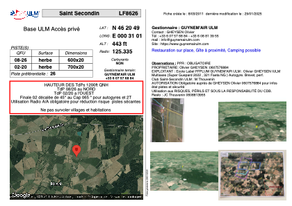


LF8626 - Saint Secondin
Located in Saint-Secondin, France
ICAO - , IATA -
Data provided by AirmateGeneral information
Coordinates: N46°20'49" E0°31'1"
Elevation is 443 feet MSL.
View others Airports in Poitou-Charentes
Operational data
Special qualification required
Current time UTC:
Current local time:
Weather at : LFBI - Poitiers Biard ( 31 km )
METAR: LFBI 221300Z AUTO 27008KT 9999 SCT024/// SCT056/// BKN076/// ///CB 17/11 Q1015 TEMPO 3000 SHRA
TAF: TAF LFBI 221100Z 2212/2312 26005KT 9999 BKN030 TEMPO 2212/2216 3000 SHRA BKN030CB PROB30 TEMPO 2212/2215 TSRA PROB30 TEMPO 2303/2307 3000 BR BKN004 TEMPO 2307/2312 4000 SHRA BKN030CB
Communications frequencies: [VIEW]
Runways:
| RWY identifier | QFU | Length (ft) | Width (ft) | Surface | LDA (ft) |
| 08 | 0° | 1968 | 65 | GRASS | |
| 26 | 0° | 1968 | 65 | GRASS |
Airport contact information
Address: Saint-Secondin France