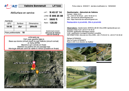


LF7332 - Valloire Bonnenuit
Located in Bonnenuit, France
ICAO - , IATA -
Data provided by AirmateGeneral information
Coordinates: N45°7'14" E6°25'8"
Elevation is 5600 feet MSL.
View others Airports in Rhône Alpes
Operational data
Special qualification required
Current time UTC:
Current local time:
Weather at : LFLB - Chambery Aix Les Bains ( 71 km )
METAR: LFLB 221300Z AUTO VRB03KT 9999 FEW033 BKN084 19/10 Q1014 TEMPO 4500 SHRA SCT040TCU
TAF: TAF LFLB 220800Z 2209/2309 VRB02KT 9999 BKN040 PROB30 TEMPO 2209/2212 -SHRA SCT025TCU PROB40 TEMPO 2212/2224 36010KT 4500 SHRA SCT040TCU PROB30 TEMPO 2215/2220 -TSRA SCT030CB TEMPO 2306/2309 4000 SHRA SCT014 FEW030CB BKN040TCU
Communications frequencies: [VIEW]
Runways:
| RWY identifier | QFU | Length (ft) | Width (ft) | Surface | LDA (ft) |
| 18 | 0° | 951 | 98 | ASPH | |
| 36 | 0° | 951 | 98 | ASPH |
Airport contact information
Address: Bonnenuit France