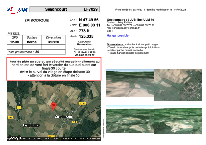


LF7029 - Senoncourt
Located in Senoncourt, France
ICAO - , IATA -
Data provided by AirmateGeneral information
Coordinates: N47°49'56" E6°3'11"
Elevation is 778 feet MSL.
View others Airports in Franche-Comté
Operational data
Special qualification required
Current time UTC:
Current local time:
Weather at : LFSX - Luxeuil Saint Sauveur ( 24 km )
METAR: LFSX 221500Z AUTO 01005KT 9999 FEW033/// BKN056/// OVC100/// ///CB 17/13 Q1014
TAF: TAF LFSX 221400Z 2215/2315 25005KT 9999 BKN030 BKN045 TEMPO 2215/2223 3500 SHRA BKN030TCU PROB40 TEMPO 2215/2222 VRB15G25KT 2500 TSRA BKN025CB PROB30 TEMPO 2300/2306 0500 FG VV/// BECMG 2306/2308 SCT010CB BKN040 TEMPO 2309/2315 VRB15G30KT 2500 TSRA BKN020CB
Communications frequencies: [VIEW]
Runways:
| RWY identifier | QFU | Length (ft) | Width (ft) | Surface | LDA (ft) |
| 12 | 0° | 1148 | 65 | GRASS | |
| 30 | 0° | 1148 | 65 | GRASS |
Airport contact information
Address: Senoncourt France