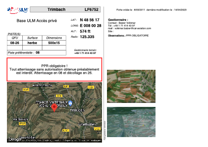


LF6752 - Trimbach
Located in Trimbach, France
ICAO - , IATA -
Data provided by AirmateGeneral information
Coordinates: N48°56'17" E8°0'28"
Elevation is 574 feet MSL.
View others Airports in Alsace
Operational data
Special qualification required
Current time UTC:
Current local time:
Weather at : EDSB - Karlsruhe/Baden-Baden ( 18 km )
METAR: EDSB 151850Z 01005KT CAVOK 17/15 Q1004
TAF: TAF EDSB 151700Z 1518/1618 01006KT 9999 SCT020 BKN035 BECMG 1518/1521 07004KT PROB40 TEMPO 1518/1601 3500 TSRA SCT012 BKN020CB BECMG 1601/1604 21006KT 4000 BR PROB40 TEMPO 1604/1608 1200 BCFG BKN004 BECMG 1607/1610 9999 PROB40 TEMPO 1610/1618 22015G25KT 4000 TSRA BKN014 BKN020CB
Communications frequencies: [VIEW]
Runways:
| RWY identifier | QFU | Length (ft) | Width (ft) | Surface | LDA (ft) |
| 08 | 0° | 1640 | 49 | GRASS | |
| 26 | 0° | 1640 | 49 | GRASS |
Airport contact information
Address: Trimbach France