


LF6658 - Llauro
Located in Llauro, France
ICAO - , IATA -
Data provided by AirmateGeneral information
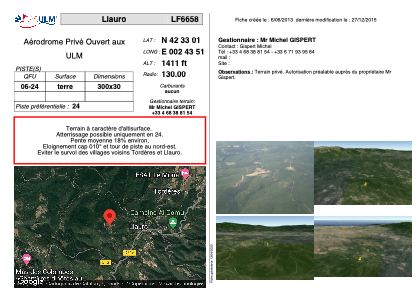
Coordinates: N42°33'1" E2°43'51"
Elevation is 1411 feet MSL.
View others Airports in Languedoc-Roussillon
Operational data
Special qualification required
Current time UTC:
Current local time:
Weather at : LFMP - Perpignan Rivesaltes ( 24 km )
METAR: LFMP 220700Z AUTO 29008KT 250V320 9999 BKN066 BKN078 17/09 Q1016 NOSIG
TAF: TAF LFMP 220200Z 2203/2303 20010KT CAVOK BECMG 2212/2214 13010KT BECMG 2220/2222 32015G25KT
Communications frequencies: [VIEW]
Runways:
| RWY identifier | QFU | Length (ft) | Width (ft) | Surface | LDA (ft) |
| 06 | 0° | 984 | 98 | DIRT | |
| 24 | 0° | 984 | 98 | DIRT |
Airport contact information
Address: Llauro France