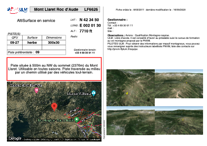


LF6626 - Mont Llaret Roc d'Aude
Located in Les Angles, France
ICAO - , IATA -
Data provided by AirmateGeneral information
Coordinates: N42°34'50" E2°1'30"
Elevation is 7710 feet MSL.
View others Airports in Languedoc-Roussillon
Operational data
Special qualification required
Current time UTC:
Current local time:
Weather at : LESU - Andorra-La Seu D'urgell ( 57 km )
TAF: TAF LESU 171400Z 1715/1815 VRB04KT 9999 SCT030 TX21/1815Z TN06/1805Z PROB40 TEMPO 1715/1804 4000 RA PROB30 1715/1720 TSRA FEW030CB TEMPO 1800/1806 3000 SHRA SCT020TCU
Communications frequencies: [VIEW]
Runways:
| RWY identifier | QFU | Length (ft) | Width (ft) | Surface | LDA (ft) |
| 09 | 0° | 984 | 98 | GRASS | |
| 27 | 0° | 984 | 98 | GRASS |
Airport contact information
Address: Les Angles France