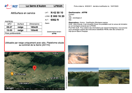


LF6525 - La Serre d'Aulon
Located in Aulon, France
ICAO - , IATA -
Data provided by AirmateGeneral information
Coordinates: N42°50'10" E0°16'20"
Elevation is 6562 feet MSL.
View others Airports in Midi-Pyrénées
Operational data
Special qualification required
Current time UTC:
Current local time:
Weather at : LFBT - Tarbes Lourdes Pyrenees ( 45 km )
METAR: LFBT 220700Z AUTO 13003KT 090V180 CAVOK 13/09 Q1018 NOSIG
TAF: TAF LFBT 220500Z 2206/2306 VRB03KT CAVOK PROB30 TEMPO 2211/2224 -SHRA FEW030CB SCT045TCU PROB40 TEMPO 2213/2220 4000 SHRA FEW030CB BKN040TCU PROB40 TEMPO 2216/2218 VRB15KT TSRA BKN014 SCT025CB PROB40 TEMPO 2218/2220 BKN012
Communications frequencies: [VIEW]
Runways:
| RWY identifier | QFU | Length (ft) | Width (ft) | Surface | LDA (ft) |
| 09 | 0° | 590 | 82 | SNOW | |
| 27 | 0° | 590 | 82 | SNOW |
Airport contact information
Address: Aulon France