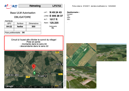


LF5753 - Rémeling
Located in Rémeling, France
ICAO - , IATA -
Data provided by AirmateGeneral information
Coordinates: N49°24'43" E6°28'37"
Elevation is 1017 feet MSL.
View others Airports in Lorraine
Operational data
Special qualification required
Current time UTC:
Current local time:
Weather at : ELLX - Luxembourg ( 31 km )
METAR: ELLX 172050Z 28011KT 9999 SCT009 BKN060 12/10 Q1009 NOSIG
TAF: TAF ELLX 171700Z 1718/1824 27013KT 6000 RA BKN007 BECMG 1719/1722 -RA BKN015 BECMG 1723/1802 BKN007 TEMPO 1803/1809 3000 -DZ BKN003 BECMG 1809/1812 BKN015 PROB40 TEMPO 1812/1820 4000 SHRA SCT015CB
Communications frequencies: [VIEW]
Runways:
| RWY identifier | QFU | Length (ft) | Width (ft) | Surface | LDA (ft) |
| 04 | 0° | 984 | 0 | GRASS | |
| 22 | 0° | 984 | 0 | GRASS |
Airport contact information
Address: Rémeling France