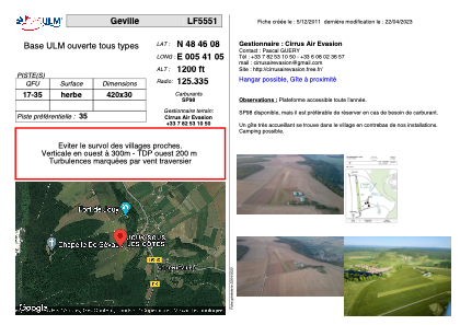


LF5551 - Geville
Located in Geville, France
ICAO - , IATA -
Data provided by AirmateGeneral information
Coordinates: N48°46'8" E5°41'5"
Elevation is 1200 feet MSL.
View others Airports in Lorraine
Operational data
Special qualification required
Current time UTC:
Current local time:
Weather at : LFSO - Nancy Ochey ( 29 km )
METAR: LFSO 160530Z AUTO 24008KT 9999 OVC010 12/11 Q1006 BECMG FEW008 BKN015
TAF: TAF LFSO 160505Z 1605/1703 23005KT 9999 FEW008 BKN015 BECMG 1608/1610 22010KT BKN020 TEMPO 1611/1620 -SHRA SCT030CB PROB40 TEMPO 1612/1618 4000 TSRA BKN030CB
Communications frequencies: [VIEW]
Runways:
| RWY identifier | QFU | Length (ft) | Width (ft) | Surface | LDA (ft) |
| 17 | 0° | 1377 | 98 | GRASS | |
| 35 | 0° | 1377 | 98 | GRASS |
Airport contact information
Address: Geville France