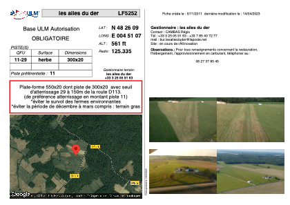


LF5252 - les ailes du der
Located in Sommevoire, France
ICAO - , IATA -
Data provided by AirmateGeneral information
Coordinates: N48°26'9" E4°51'7"
Elevation is 561 feet MSL.
View others Airports in Champagne-Ardenne
Operational data
Special qualification required
Current time UTC:
Current local time:
Weather at : LFSI - Saint Dizier Robinson ( 22 km )
METAR: LFSI 171400Z AUTO 28008KT CAVOK 18/10 Q1010
TAF: TAF LFSI 170800Z 1709/1809 25005KT 9999 BKN035 TEMPO 1709/1719 4000 SHRA BKN025TCU
Communications frequencies: [VIEW]
Runways:
| RWY identifier | QFU | Length (ft) | Width (ft) | Surface | LDA (ft) |
| 11 | 0° | 984 | 65 | GRASS | |
| 29 | 0° | 984 | 65 | GRASS |
Airport contact information
Address: Sommevoire France