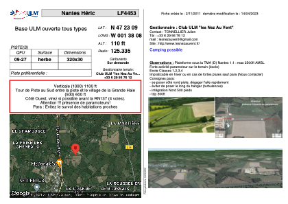


LF4453 - Nantes Héric
Located in Héric, France
ICAO - , IATA -
Data provided by AirmateGeneral information
Coordinates: N47°23'9" W1°38'8"
Elevation is 110 feet MSL.
View others Airports in Pays-de-la-Loire
Operational data
Special qualification required
Current time UTC:
Current local time:
Weather at : LFRS - Nantes Atlantique ( 26 km )
METAR: LFRS 221500Z AUTO 24014KT 9999 FEW025 SCT031 BKN064 18/13 Q1014 NOSIG
TAF: TAF LFRS 221100Z 2212/2318 25008KT 9999 SCT035 BKN075 TEMPO 2212/2215 3000 SHRA BKN030CB TEMPO 2308/2312 3000 SHRA BKN025CB PROB30 TEMPO 2312/2318 -SHRA SCT030CB
Communications frequencies: [VIEW]
Runways:
| RWY identifier | QFU | Length (ft) | Width (ft) | Surface | LDA (ft) |
| 09 | 0° | 1049 | 98 | GRASS | |
| 27 | 0° | 1049 | 98 | GRASS |
Airport contact information
Address: Héric France