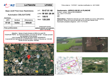


LF4452 - La Planche
Located in La Planche, France
ICAO - , IATA -
Data provided by AirmateGeneral information
Coordinates: N47°1'40" W1°26'4"
Elevation is 105 feet MSL.
View others Airports in Pays-de-la-Loire
Operational data
Special qualification required
Current time UTC:
Current local time:
Weather at : LFRS - Nantes Atlantique ( 19 km )
METAR: LFRS 151830Z AUTO 22004KT 9999 SCT029 SCT039 BKN066 13/10 Q1005 NOSIG
TAF: TAF LFRS 151700Z 1518/1624 22008KT 9999 FEW012 SCT030 BKN050 BECMG 1518/1520 15007KT TEMPO 1604/1622 3000 SHRA SCT012 BKN020TCU PROB30 TEMPO 1605/1607 BKN005 TEMPO 1608/1620 BKN010 BKN018CB
Communications frequencies: [VIEW]
Runways:
| RWY identifier | QFU | Length (ft) | Width (ft) | Surface | LDA (ft) |
| 07 | 0° | 1312 | 65 | GRASS | |
| 25 | 0° | 1312 | 65 | GRASS |
Airport contact information
Address: La Planche France