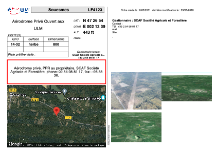


LF4123 - Souesmes
Located in Souesmes, France
ICAO - , IATA -
Data provided by AirmateGeneral information
Coordinates: N47°26'54" E2°12'39"
Elevation is 443 feet MSL.
View others Airports in Centre
Operational data
Special qualification required
Current time UTC:
Current local time:
Weather at : LFYR - Romorantin Pruniers ( 42 km )
METAR: LFYR 151800Z AUTO VRB03KT 9999 -RA //////TCU 13/11 Q1006
TAF: TAF LFYR 151400Z 1515/1615 20007KT 9999 BKN040 TEMPO 1515/1520 VRB10G20KT 4000 SHRA BKN040CB PROB40 TEMPO 1515/1519 VRB15G30KT 2000 TSRA BKN040CB PROB30 TEMPO 1602/1605 0500 FG TEMPO 1610/1615 4000 SHRA BKN030CB
Communications frequencies: [VIEW]
Runways:
| RWY identifier | QFU | Length (ft) | Width (ft) | Surface | LDA (ft) |
| 14 | 0° | 2624 | 0 | GRASS | |
| 32 | 0° | 2624 | 0 | GRASS |
Airport contact information
Address: Souesmes France