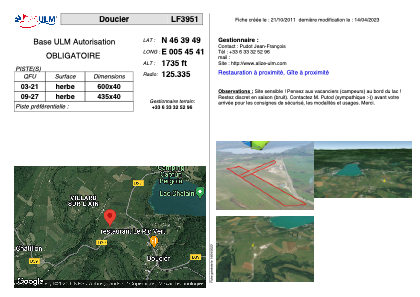


LF3951 - Doucier
Located in Doucier, France
ICAO - , IATA -
Data provided by AirmateGeneral information
Coordinates: N46°39'49" E5°45'41"
Elevation is 1735 feet MSL.
View others Airports in Franche-Comté
Operational data
Special qualification required
Current time UTC:
Current local time:
Weather at : LFGJ - Dole Tavaux ( 49 km )
METAR: LFGJ 160930Z AUTO VRB02KT 9999 SCT018 BKN032 OVC076 15/11 Q1007 NOSIG
TAF: TAF LFGJ 160800Z 1609/1618 23005KT 9999 FEW012 BKN045 PROB40 TEMPO 1609/1610 BKN010 PROB40 TEMPO 1612/1618 3000 SHRA FEW040CB PROB40 TEMPO 1614/1618 TSRA BKN033CB
Communications frequencies: [VIEW]
Runways:
| RWY identifier | QFU | Length (ft) | Width (ft) | Surface | LDA (ft) |
| 03 | 0° | 1968 | 131 | GRASS | |
| 21 | 0° | 1968 | 131 | GRASS |
Airport contact information
Address: Doucier France