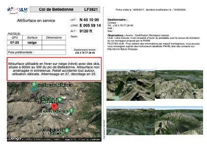


LF3821 - Col de Belledonne
Located in Revel, France
ICAO - , IATA -
Data provided by AirmateGeneral information
Coordinates: N45°9'60" E5°59'14"
Elevation is 9120 feet MSL.
View others Airports in Rhône Alpes
Operational data
Special qualification required
Current time UTC:
Current local time:
Weather at : LFLB - Chambery Aix Les Bains ( 53 km )
TAF: TAF LFLB 151400Z 1515/1615 VRB05KT 9999 BKN050 TEMPO 1515/1524 4000 SHRA BKN014 BKN035TCU PROB40 TEMPO 1515/1519 VRB15G25KT 2000 TSRA BKN012 BKN030CB PROB30 TEMPO 1600/1606 2000 BR BKN004 TEMPO 1610/1615 SHRA SCT030TCU BKN050 PROB30 TEMPO 1612/1615 VRB15KT 2500 TSRA BKN025CB
Communications frequencies: [VIEW]
Runways:
| RWY identifier | QFU | Length (ft) | Width (ft) | Surface | LDA (ft) |
| 07 | 0° | 0 | 0 | SNOW | |
| 25 | 0° | 0 | 0 | SNOW |
Airport contact information
Address: Revel France