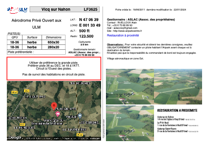


LF3625 - Vicq sur Nahon
Located in Vicq-sur-Nahon, France
ICAO - , IATA -
Data provided by AirmateGeneral information
Coordinates: N47°6'39" E1°33'49"
Elevation is 500 feet MSL.
View others Airports in Centre
Operational data
Special qualification required
Current time UTC:
Current local time:
Weather at : LFYR - Romorantin Pruniers ( 25 km )
METAR: LFYR 221030Z AUTO 23006KT 150V280 9999 FEW027/// SCT038/// BKN084/// //////TCU 18/13 Q1014 TEMPO 28015G35KT 2000 -TSRAGS SCT015 BKN025CB
TAF: TAF LFYR 220800Z 2209/2309 24005KT 9999 BKN010 BECMG 2209/2210 SCT020 TEMPO 2210/2219 25015G25KT 4000 SHRA BKN025CB PROB40 TEMPO 2212/2218 28015G35KT 2000 -TSRAGS SCT015 BKN025CB TEMPO 2222/2302 4000 SHRA SCT012 SCT020CB TEMPO 2304/2308 4000 BR BKN004
Communications frequencies: [VIEW]
Runways:
| RWY identifier | QFU | Length (ft) | Width (ft) | Surface | LDA (ft) |
| 18 | 0° | 2132 | 98 | GRASS | |
| 36 | 0° | 2132 | 98 | GRASS |
Airport contact information
Address: Vicq-sur-Nahon France