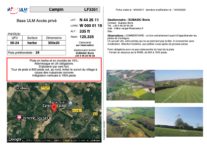


LF3351 - Campin
Located in Grignols, France
ICAO - , IATA -
Data provided by AirmateGeneral information
Coordinates: N44°26'11" W0°1'19"
Elevation is 335 feet MSL.
View others Airports in Aquitaine
Operational data
Special qualification required
Current time UTC:
Current local time:
Weather at : LFBA - Agen La Garenne ( 57 km )
METAR: LFBA 221130Z AUTO 34005KT 280V020 9999 SCT034 BKN043 BKN072 19/11 Q1017 BECMG SCT018TCU BKN040
TAF: TAF LFBA 221100Z 2212/2221 32005KT 9999 SCT025TCU SCT060 BECMG 2215/2217 SCT030 FEW040CB BKN080 PROB30 TEMPO 2217/2221 TSRA
Communications frequencies: [VIEW]
Runways:
| RWY identifier | QFU | Length (ft) | Width (ft) | Surface | LDA (ft) |
| 06 | 0° | 984 | 65 | GRASS | |
| 24 | 0° | 984 | 65 | GRASS |
Airport contact information
Address: Grignols France