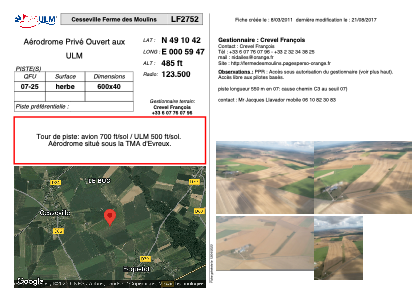


LF2752 - Cesseville Ferme des Moulins
Located in Cesseville, France
ICAO - , IATA -
Data provided by AirmateGeneral information
Coordinates: N49°10'42" E0°59'47"
Elevation is 485 feet MSL.
View others Airports in Upper Normandy
Operational data
Special qualification required
Current time UTC:
Current local time:
Weather at : LFOE - Evreux Fauville ( 23 km )
METAR: LFOE 151930Z AUTO 23006KT CAVOK 13/09 Q1006 BECMG 17010KT
TAF: TAF LFOE 151400Z 1515/1615 17010KT 9999 BKN035 PROB40 TEMPO 1515/1519 4000 -SHRA BKN030CB TEMPO 1603/1607 4000 -RA
Communications frequencies: [VIEW]
Runways:
| RWY identifier | QFU | Length (ft) | Width (ft) | Surface | LDA (ft) |
| 07 | 0° | 1968 | 131 | GRASS | |
| 25 | 0° | 1968 | 131 | GRASS |
Airport contact information
Address: Cesseville France