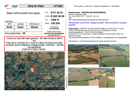


LF1826 - Sury en Vaux
Located in Sury-en-Vaux, France
ICAO - , IATA -
Data provided by AirmateGeneral information
Coordinates: N47°22'51" E2°46'58"
Elevation is 1000 feet MSL.
View others Airports in Burgundy
Operational data
Special qualification required
Current time UTC:
Current local time:
Weather at : LFOA - Avord ( 38 km )
METAR: LFOA 160630Z AUTO 25006KT 9999 FEW005 11/09 Q1007 TEMPO BKN013
TAF: TAF AMD LFOA 160500Z 1605/1703 22005KT CAVOK TX17/1613Z TN08/1605Z TEMPO 1607/1609 BKN013 TEMPO 1612/1618 3000 SHRA BKN035TCU PROB40 TEMPO 1614/1616 TSGS BKN030CB TEMPO 1701/1703 4000 BR
Communications frequencies: [VIEW]
Runways:
| RWY identifier | QFU | Length (ft) | Width (ft) | Surface | LDA (ft) |
| 08 | 0° | 984 | 65 | GRASS | |
| 26 | 0° | 984 | 65 | GRASS |
Airport contact information
Address: Sury-en-Vaux France