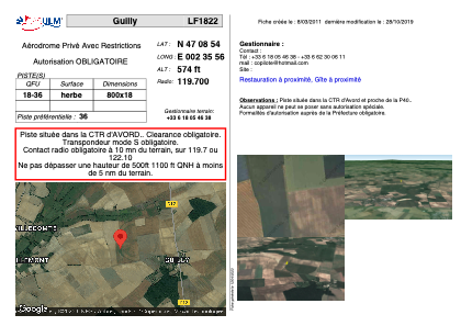


LF1822 - Guilly
Located in Brécy, France
ICAO - , IATA -
Data provided by AirmateGeneral information
Coordinates: N47°8'54" E2°35'56"
Elevation is 574 feet MSL.
View others Airports in Centre
Operational data
Special qualification required
Current time UTC:
Current local time:
Weather at : LFOA - Avord ( 11 km )
METAR: LFOA 221630Z AUTO 27010KT 240V300 9999 SCT038/// BKN048/// BKN058/// //////CB 17/12 Q1015
TAF: TAF LFOA 221400Z 2215/2315 22005KT 9999 BKN040 TX19/2215Z TN10/2305Z TEMPO 2215/2221 27015G25KT 4000 SHRA BKN030CB PROB40 TEMPO 2215/2218 VRB15G30KT 2000 TSRA SCT010 BKN030CB TEMPO 2300/2307 BKN005 PROB40 TEMPO 2300/2303 4000 SHRA BKN015TCU TEMPO 2311/2315 VRB15G25KT 2000 TSRA BKN040CB
Communications frequencies: [VIEW]
Runways:
| RWY identifier | QFU | Length (ft) | Width (ft) | Surface | LDA (ft) |
| 18 | 0° | 2624 | 59 | GRASS | |
| 36 | 0° | 2624 | 59 | GRASS |
Airport contact information
Address: Brécy France