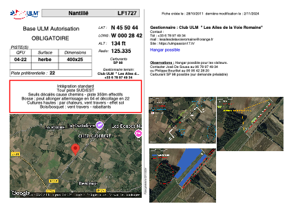


LF1727 - Nantillé
Located in Nantillé, France
ICAO - , IATA -
Data provided by AirmateGeneral information
Coordinates: N45°50'44" W0°28'42"
Elevation is 134 feet MSL.
View others Airports in Poitou-Charentes
Operational data
Special qualification required
Current time UTC:
Current local time:
Weather at : LFBG - Cognac Chateaubernard ( 24 km )
METAR: LFBG 220930Z AUTO 27007KT 190V310 9999 BKN023/// BKN033/// BKN040/// //////CB 17/13 Q1016 TEMPO 4000 SHRA
TAF: TAF LFBG 220800Z 2209/2309 22010KT 9999 SCT020 BKN040 TEMPO 2209/2213 4000 SHRA BKN025CB TEMPO 2212/2216 26012G25KT TEMPO 2219/2303 4000 SHRA BKN025TCU TEMPO 2307/2309 4000 SHRA BKN025TCU
Communications frequencies: [VIEW]
Runways:
Airport contact information
Address: Nantillé France