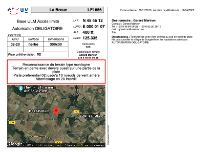


LF1656 - La Broue
Located in Genac Bignac, France
ICAO - , IATA -
Data provided by AirmateGeneral information
Coordinates: N45°46'12" E0°1'7"
Elevation is 400 feet MSL.
View others Airports in Poitou-Charentes
Operational data
Special qualification required
Current time UTC:
Current local time:
Weather at : LFBU - Angouleme Brie Champniers ( 16 km )
METAR: LFBU 221530Z AUTO VRB03KT 9999 FEW049/// SCT062/// OVC074/// ///CB 15/12 Q1016 BECMG BKN030
TAF: TAF AMD LFBU 221401Z 2214/2312 24005KT 9999 BKN030 TEMPO 2214/2216 4000 SHRA BKN015 FEW020CB BKN025TCU PROB40 TEMPO 2214/2216 24015G25KT 2000 TSRA BKN012 BKN020CB TEMPO 2302/2306 0600 FG VV/// TEMPO 2306/2309 BKN010
Communications frequencies: [VIEW]
Runways:
| RWY identifier | QFU | Length (ft) | Width (ft) | Surface | LDA (ft) |
| 02 | 0° | 984 | 98 | GRASS | |
| 20 | 0° | 984 | 98 | GRASS |
Airport contact information
Address: Genac Bignac France