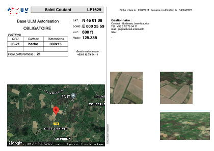


LF1629 - Saint Coutant
Located in Saint-Coutant, France
ICAO - , IATA -
Data provided by AirmateGeneral information
Coordinates: N46°1'8" E0°25'59"
Elevation is 600 feet MSL.
View others Airports in Poitou-Charentes
Operational data
Special qualification required
Current time UTC:
Current local time:
Weather at : LFBU - Angouleme Brie Champniers ( 36 km )
METAR: LFBU 170200Z AUTO 11003KT CAVOK 08/07 Q1008
TAF: TAF LFBU 161700Z 1618/1718 30010KT 9999 BKN040 TEMPO 1618/1619 3000 SHRA BKN040TCU BECMG 1619/1621 13005KT PROB40 1621/1706 3000 BR BKN003 PROB30 1702/1705 0400 FG VV/// TEMPO 1708/1718 3000 SHRA BKN040TCU PROB40 TEMPO 1712/1718 SCT040CB
Communications frequencies: [VIEW]
Runways:
| RWY identifier | QFU | Length (ft) | Width (ft) | Surface | LDA (ft) |
| 03 | 0° | 1082 | 49 | GRASS | |
| 21 | 0° | 1082 | 49 | GRASS |
Airport contact information
Address: Saint-Coutant France