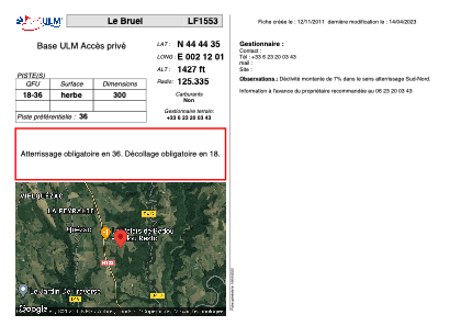


LF1553 - Le Bruel
Located in Quézac, France
ICAO - , IATA -
Data provided by AirmateGeneral information
Coordinates: N44°44'35" E2°12'1"
Elevation is 1427 feet MSL.
View others Airports in Auvergne
Operational data
Special qualification required
Current time UTC:
Current local time:
Weather at : LFLW - Aurillac ( 24 km )
TAF: TAF LFLW 151400Z 1515/1524 29005KT 9999 FEW020TCU BKN040 TEMPO 1515/1524 30015KT 4000 SHRA BKN014TCU PROB30 TEMPO 1515/1524 VRB15G30KT 1500 TSRA BKN010CB
Communications frequencies: [VIEW]
Runways:
| RWY identifier | QFU | Length (ft) | Width (ft) | Surface | LDA (ft) |
| 18 | 0° | 984 | 0 | GRASS | |
| 36 | 0° | 984 | 0 | GRASS |
Airport contact information
Address: Quézac France