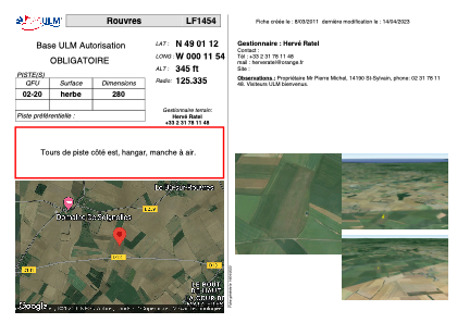


LF1454 - Rouvres
Located in Rouvres, France
ICAO - , IATA -
Data provided by AirmateGeneral information
Coordinates: N49°1'12" W0°11'54"
Elevation is 345 feet MSL.
View others Airports in Lower Normandy
Operational data
Special qualification required
Current time UTC:
Current local time:
Weather at : LFRK - Caen Carpiquet ( 25 km )
METAR: LFRK 171130Z AUTO 18008KT 140V230 9999 FEW034 SCT040 19/11 Q1010 TEMPO 3000 SHRA SCT035CB
TAF: TAF LFRK 171100Z 1712/1721 VRB05KT 9999 BKN030 TEMPO 1713/1721 3000 SHRA SCT035CB PROB40 TEMPO 1716/1720 1400 -TSRAGS BKN025CB
Communications frequencies: [VIEW]
Runways:
| RWY identifier | QFU | Length (ft) | Width (ft) | Surface | LDA (ft) |
| 02 | 0° | 918 | 0 | GRASS | |
| 20 | 0° | 918 | 0 | GRASS |
Airport contact information
Address: Rouvres France