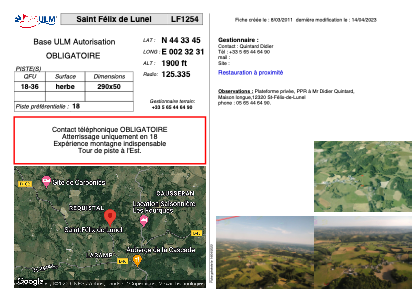


LF1254 - Saint Félix de Lunel
Located in Saint-Félix-de-Lunel, France
ICAO - , IATA -
Data provided by AirmateGeneral information
Coordinates: N44°33'45" E2°32'31"
Elevation is 1900 feet MSL.
View others Airports in Midi-Pyrénées
Operational data
Special qualification required
Current time UTC:
Current local time:
Weather at : LFCR - Rodez Aveyron ( 18 km )
METAR: LFCR 152030Z AUTO 29003KT 9999 DZ FEW032/// BKN045/// OVC052/// ///CB 09/09 Q1009 TEMPO 3000 BR BECMG NSC
TAF: TAF AMD LFCR 151829Z 1518/1618 31004KT CAVOK PROB40 TEMPO 1518/1521 SHRA SCT030TCU PROB40 1522/1606 3000 BR PROB30 1600/1605 0600 FG VV/// PROB40 TEMPO 1609/1618 SHRA FEW025CB SCT035TCU PROB30 TEMPO 1616/1618 TSRA
Communications frequencies: [VIEW]
Runways:
| RWY identifier | QFU | Length (ft) | Width (ft) | Surface | LDA (ft) |
| 18 | 0° | 951 | 164 | GRASS | |
| 36 | 0° | 951 | 164 | GRASS |
Airport contact information
Address: Saint-Félix-de-Lunel France