


LEVE - Virgen de la Estrella
Located in Los Santos de Maimona, Spain
ICAO - , IATA -
Data provided by AirmateGeneral information
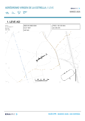
Coordinates: N38°25'14" W6°21'26"
Elevation is 1850 feet MSL.
Magnetic variation is -1° East View others Airports in Badajoz
Operational data
Special qualification required
Current time UTC:
Current local time:
Weather at : LEBZ - Badajoz/Talavera La Real ( 66 km )
METAR: LEBZ 151730Z 27013KT CAVOK 20/07 Q1011
TAF: TAF LEBZ 151400Z 1515/1615 28009KT CAVOK TX21/1615Z TN08/1606Z TEMPO 1515/1517 29015G25KT
Communications frequencies: [VIEW]
Runways:
| RWY identifier | QFU | Length (ft) | Width (ft) | Surface | LDA (ft) |
| 06 | 56° | 939 | 43 | DIRT | |
| 24 | 236° | 939 | 43 | DIRT |
Airport contact information
Address: Los Santos de Maimona Spain