


LETE - Morante (Badajoz)
Located in Morante (Badajoz), Spain
ICAO - LETE, IATA -
Data provided by AirmateGeneral information
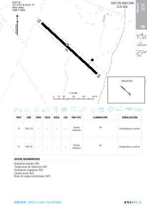
Coordinates: N39°2'13" W6°41'26"
Elevation is 699 feet MSL.
Magnetic variation is -1° East View others Airports in Extremadura
Operational data
Special qualification required
Current time UTC:
Current local time:
Weather at : LEBZ - Badajoz/Talavera La Real ( 20 km )
METAR: LEBZ 150700Z 27009KT CAVOK 11/09 Q1013
TAF: TAF LEBZ 150200Z 1503/1603 29005KT CAVOK TX21/1515Z TN10/1506Z BECMG 1512/1514 29015KT TEMPO 1514/1517 29015G25KT
Communications frequencies: [VIEW]
Runways:
| RWY identifier | QFU | Length (ft) | Width (ft) | Surface | LDA (ft) |
| 13 | 127° | 2792 | 140 | DIRT | |
| 31 | 307° | 2792 | 140 | DIRT |
Airport contact information
Address: Morante (Badajoz) Spain