


LERO - CAstro Rozas
Located in Rozas (Lugo), Spain
ICAO - LERO, IATA -
Data provided by AirmateGeneral information
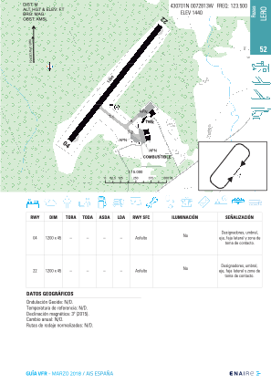
Coordinates: N43°6'52" W7°27'54"
Elevation is 1440 feet MSL.
Magnetic variation is -1° East View others Airports in Lugo
Operational data
Special qualification required
Current time UTC:
Current local time:
Weather at : LECO - A Coruna ( 77 km )
METAR: LECO 162100Z 17004KT 9999 SCT021 BKN031 11/09 Q1009 NOSIG
TAF: TAF LECO 162000Z 1621/1721 24009KT 9999 SCT020 BKN030 TX16/1715Z TN10/1704Z PROB40 TEMPO 1621/1721 3000 SHRA SCT030TCU TEMPO 1709/1720 30010KT
Communications frequencies: [VIEW]
Runways:
| RWY identifier | QFU | Length (ft) | Width (ft) | Surface | LDA (ft) |
| 04 | 35° | 3905 | 143 | ASPH | |
| 22 | 215° | 3905 | 143 | ASPH |
Airport contact information
Address: Rozas (Lugo) Spain
