


L39 - Leesville
Located in Leesville, United States
ICAO - L39, IATA -
Data provided by AirmateGeneral information
Coordinates: N31°10'5" W93°20'33"
Elevation is 282 feet MSL.
Magnetic variation is 02° East View others Airports in Louisiana
Operational data
Special qualification required
Current time UTC:
Current local time:
Weather at : KPOE - Maks Aaf ( 20 km )
METAR: KPOE 090455Z AUTO 18010KT 10SM OVC009 26/24 A2968 RMK AO2 SLP049 T02590241
TAF: TAF AMD KPOE 090438Z 0904/1005 17012KT 9999 BKN009 QNH2968INS BECMG 0905/0906 17012KT 9999 OVC008 QNH2970INS BECMG 0908/0909 VRB06KT 8000 BR OVC008 QNH2969INS TEMPO 0910/0913 3200 BR OVC005 BECMG 0914/0915 21009KT 9999 NSW OVC010 QNH2980INS BECMG 0916/0917 21009KT 9999 SCT015 BKN035 QNH2978INS BECMG 0918/0919 18009KT 9999 SCT020 OVC032 QNH2974INS BECMG 0920/0921 VRB06KT 9999 BKN020 OVC035 QNH2971INS BECMG 0922/0923 VRB15G25KT 9999 VCTS BKN015CB OVC025 QNH2970INS BECMG 1002/1003 VRB25G35KT 3200 TSRA SCT007 BKN017CB OVC030 QNH2980INS TX33/0922Z TN24/0912Z
Communications frequencies: [VIEW]
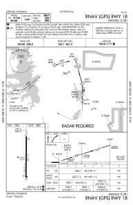
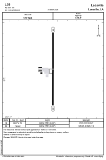
Runways:
| RWY identifier | QFU | Length (ft) | Width (ft) | Surface | LDA (ft) |
| 18 | 180° | 3807 | 75 | ASPH | |
| 36 | 360° | 3807 | 75 | ASPH |
Airport contact information
Address: Leesville United States