


L31 - St Tammany Rgnl
Located in Covington, United States
ICAO - L31, IATA -
Data provided by AirmateGeneral information
Coordinates: N30°26'42" W89°59'20"
Elevation is 39 feet MSL.
Magnetic variation is 02° East View others Airports in Louisiana
Operational data
Special qualification required
Current time UTC:
Current local time:
Weather at : KASD - Slidell ( 19 km )
TAF: KASD 090238Z 0903/0924 17014KT P6SM SCT015 OVC035 TEMPO 0903/0906 BKN015 FM090600 18010KT P6SM BKN015 OVC025 FM091500 19010KT P6SM BKN025 FM092000 19012KT P6SM SCT035
Communications frequencies: [VIEW]
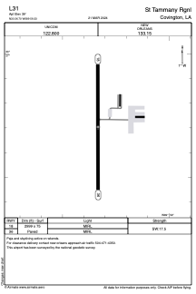
Runways:
| RWY identifier | QFU | Length (ft) | Width (ft) | Surface | LDA (ft) |
| 18 | 180° | 2999 | 75 | ASPH | |
| 36 | 360° | 2999 | 75 | ASPH |
Airport contact information
Address: Covington United States
