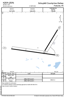


KZER - Schuylkill County/Joe Zerbey
Located in Pottsville, United States
ICAO - ZER, IATA -
Data provided by AirmateGeneral information
Coordinates: N40°42'24" W76°22'26"
Elevation is 1729 feet MSL.
Magnetic variation is -12° East View others Airports in Pennsylvania
Operational data
Special qualification required
Current time UTC:
Current local time:
Communications frequencies: [VIEW]
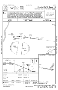
Runways:
| RWY identifier | QFU | Length (ft) | Width (ft) | Surface | LDA (ft) |
| 04 | 31° | 2523 | 140 | GRASS | |
| 22 | 211° | 2523 | 140 | GRASS | |
| 11 | 98° | 5101 | 75 | ASPH | |
| 29 | 278° | 5101 | 75 | ASPH |
Airport contact information
Address: Pottsville United States