


KYNG - Youngstown/Warren Rgnl
Located in Youngstown/Warren, United States
ICAO - YNG, IATA - YNG
Data provided by AirmateGeneral information
Coordinates: N41°15'42" W80°40'49"
Elevation is 1191 feet MSL.
Magnetic variation is -08° East View others Airports in Ohio
Operational data
Special qualification required
Current time UTC:
Current local time:
Weather
METAR: KYNG 080751Z 23010KT 10SM OVC250 18/16 A2962 RMK AO2 SLP022 T01830161 $
TAF: KYNG 080529Z 0806/0906 20011KT P6SM FEW015 SCT050 FM080900 24009KT P6SM SCT060 FM081700 25010KT P6SM FEW250 FM082300 30009KT P6SM FEW250 FM090500 04006KT P6SM BKN100
Communications frequencies: [VIEW]
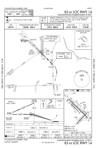
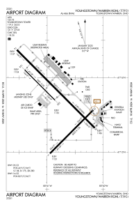
Runways:
| RWY identifier | QFU | Length (ft) | Width (ft) | Surface | LDA (ft) |
| 05 | 45° | 5002 | 150 | ASPH | 5002 |
| 23 | 225° | 5002 | 150 | ASPH | 5002 |
| 14 | 135° | 9003 | 150 | ASPH | 9003 |
| 32 | 315° | 9003 | 150 | ASPH | 9003 |
| 143 | 135° | 3501 | 60 | ASPH | 3500 |
| 323 | 315° | 3501 | 60 | ASPH | 3500 |
Airport contact information
Address: Youngstown/Warren United States