


KWRL - Worland Muni
Located in Worland, United States
ICAO - WRL, IATA - WRL
Data provided by AirmateGeneral information
Coordinates: N43°57'46" W107°57'2"
Elevation is 4251 feet MSL.
Magnetic variation is 13° East View others Airports in Wyoming
Operational data
Special qualification required
Current time UTC:
Current local time:
Weather
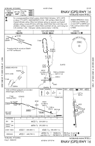
METAR: KWRL 091253Z AUTO 30007KT 10SM OVC013 06/04 A3022 RMK AO2 SLP241 T00610044
TAF: KWRL 091120Z 0912/1012 33011KT P6SM BKN015 FM091700 34010KT P6SM SCT025 BKN040 FM100200 34007KT P6SM SCT040 BKN060
Communications frequencies: [VIEW]
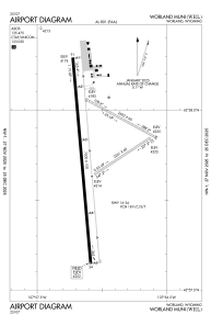
Runways:
| RWY identifier | QFU | Length (ft) | Width (ft) | Surface | LDA (ft) |
| 04 | 57° | 2241 | 60 | GRASS | 2241 |
| 22 | 237° | 2241 | 60 | GRASS | 2241 |
| 10 | 118° | 2502 | 60 | GRASS | 2501 |
| 28 | 298° | 2502 | 60 | GRASS | 2501 |
| 16 | 175° | 7000 | 100 | ASPH | 7000 |
| 34 | 355° | 7000 | 100 | ASPH | 7000 |
Airport contact information
Address: Worland United States