


KWRB - Robins Afb
Located in Warner Robins, United States
ICAO - WRB, IATA - WRB
Data provided by AirmateGeneral information
Coordinates: N32°38'25" W83°35'31"
Elevation is 294 feet MSL.
Magnetic variation is -02° East View others Airports in Georgia
Operational data
Special qualification required
Current time UTC:
Current local time:
Weather
METAR: KWRB 172155Z 16016KT 9SM RA BKN050 21/19 A2981 RMK AO2A RAE22RAB25E31RAB32 SLP095 P0007 T02090190
TAF: TAF AMD KWRB 172200Z 1722/1822 17010G15KT 9000 -SHRA SCT010 BKN020 BKN060 OVC100 QNH2980INS TEMPO 1722/1802 18010G20KT 8000 SHRA BECMG 1802/1803 19008KT 9000 -SHRA SCT008 BKN010 QNH2981INS BECMG 1809/1810 19012KT 9000 -SHRA VCTS SCT008 BKN010CB QNH2979INS TEMPO 1812/1814 VRB10G20KT 8000 -TSRA BKN009CB BECMG 1815/1816 25009KT 9999 VCSH SCT010 BKN020 QNH2990INS TEMPO 1817/1820 25012G18KT 8000 -SHRA TX22/1722Z TN18/1810Z
Communications frequencies: [VIEW]
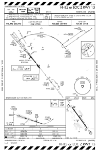
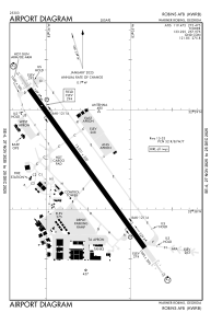
Runways:
| RWY identifier | QFU | Length (ft) | Width (ft) | Surface | LDA (ft) |
| 15 | 144° | 12001 | 300 | OTHER | |
| 33 | 324° | 12001 | 300 | OTHER |
Airport contact information
Address: Warner Robins United States