


KVNW - Van Wert County
Located in Van Wert, United States
ICAO - VNW, IATA -
Data provided by AirmateGeneral information
Coordinates: N40°51'50" W84°36'23"
Elevation is 787 feet MSL.
Magnetic variation is -05° East View others Airports in Ohio
Operational data
Special qualification required
Current time UTC:
Current local time:
Weather at : KAXV - Neil Armstrong ( 49 km )
METAR: KAXV 080555Z AUTO 22005KT 10SM SCT090 17/16 A2966 RMK AO2
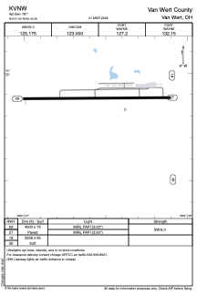
Communications frequencies: [VIEW]
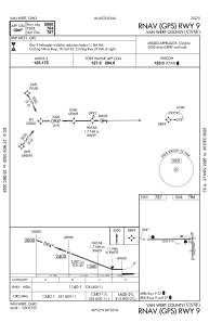
Runways:
| RWY identifier | QFU | Length (ft) | Width (ft) | Surface | LDA (ft) |
| 09 | 90° | 4000 | 75 | ASPH | |
| 27 | 270° | 4000 | 75 | ASPH | |
| 18 | 179° | 2558 | 95 | GRASS | |
| 36 | 359° | 2558 | 95 | GRASS |
Airport contact information
Address: Van Wert United States
Other aviation service providers
Flight schools

Van Wert County Regional Airport Authority
Van Wert County Regional Airport Authority
vwariport@embarqmail.com+1(419)232-4500